27 October 2016-10-26
Several years ago (and I can’t quite remember where), I read of an old, walled, deer park which existed close to Sedgefield known locally as Middleham Park. Records from an old OS 1.:25,000 (1937) failed to reveal its location, although I assumed it must be closer to the village of Bishop Middleham, with its Bishop castle ruins, one of the many old medieval agricultural villages scattered across the landscape.
‘A park surrounded Middleham Manor from as early as 1349, when it was probably used to keep deer for hunting. In 1649 it measured c.70 acres. The park was surrounded by a wall, which can still be seen in some places. The wall may be of late medieval date 15th or 16th century’.http://www.keystothepast.info/Pages/pgDetail.aspx?PRN=D1116
Recently I came across a rather useful website allowing the user to overlay old maps onto satellite images. One such map ‘OS Six Inch’ (1888-1913) clearly revealed the park and the boundary wall. Looking at the map, much of Middleham Park is now underwater.
The park is situated in one of the less known topographical features of County Durham’s landscape, the large areas of waterlogged land lying close to the parish of Sedgefield. Travelling the A1 corridor north, looking east, evidence of modern drainage can be seen criss-crossing the flat horizon. However, over the past 20 years, increased rainfall is changing the landscape back into permanent waterlogged fields and lakes.
‘The marshy ground resulted in the lands being used for fish ponds, meadowland and even a swannery probably meant that the Bishop’s Castle was surrounded with water; access restricted to a causeway between the church and the castle’.http://www.durham.gov.uk/
I decided to take my best walking buddy Doris (our little fluffy doggie) on an expedition in search of traces of the wall. Travelling long overgrown rural footpaths, and Holloways, we spent 5 hours (mostly lost) searching through bracken and bog. From the map I could also see a set of buildings named ‘Island Farm’ with causeways still visible. It’s said that the visual effect of these islands within wetland may also have held spiritual meaning… ‘This could have made an ecclesiastical base at Bishop Middleham attractive and it may also have been attractive to a secular power base because of its inherent defensibility.’ http://www.durham.gov.uk/
Almost on the verge of giving up, we paused by one of the large lakes to share a slice of flapjack. It was only then I noticed a small section of wall behind the bank of the Skerne. I couldn’t quite believe my luck and it may well be an age or a geek thing, but I quickly became very excited. As I raced, camera in hand with Doris into the evening sunset, a sudden change in her direction required a small jump whereupon I slipped, gliding momentary through the air before landing with a wet thump.
I have a small ache but also a lovely picture of the wall.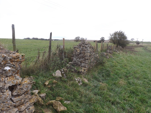
Thanks for reading.
Don’t forget to visit …www.http://keithlpalmer.com/


